Clennell Street ia a truly ancient trackway through the Cheviot hills and ultimately connects Morpeth and Kelso.
It is rewarding enough to walk from the Northumbrian village of Alwinton and head north along (or more accurately up, as you will soon realise…) Clennell Street to simply enjoy the wide-open spaces and vistas of the high hills. However, you will be walking through some of the richest evidence of the past in the area.
 These pages take a brief look at the archaeology you will encounter in the first three kilometres of your walk. They also provide an excuse for frequent stops as you ascend!
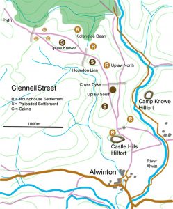
The street was once called ‘Ermspeth’ which is an Old English or Anglo-Saxon name meaning ‘Eagle’s Path’. The droving of cattle along paths such as this only died out in the post mediaeval period. These droveways are commonly cut by cross dykes whose real purpose is not known.
It is thought that they may be a means of controlling the movement of cattle, imposing some sort of toll on those using the track or possibly a way of marking territorial limits. Three of these are evident as marked on the chart. It is interesting that the dykes are associated with the settlements at Uplaw South, Hosedon Linn and Uplaw Knowe suggesting a relationship with them.
As there has been relatively little excavation carried out on the sites along Clennell Street it is not possible to put a firm date on all of the different settlements. The Kidlandlee Dean settlement may be among the earliest and could date back to almost 2000BC making it early Bronze Age.
The three palisaded settlements could well have a date around 500BC placing them in the late Bronze Age. The largest of the three settlements lies at Hosedon Linn where the marks of up to nine timber roundhouses were surrounded by the palisade. The palisade ditch here is not easy to make out but the structures inside are slightly better defined. The houses are unusual in that they have left double-ring grooves though the actual design of these buildings is unknown.
![]() The settlements at Uplaw North and Uplaw South show the familiar arrangement of stone-built houses and yards which are typical of settlements in the late Iron Age and the early Romano-British period giving an approximate date somewhere between the 5th century BC to the 5th century AD. Of course, the settlements could have earlier origins and without further investigation, it is difficult to say when the occupation of these sites actually ended.
The settlements at Uplaw North and Uplaw South show the familiar arrangement of stone-built houses and yards which are typical of settlements in the late Iron Age and the early Romano-British period giving an approximate date somewhere between the 5th century BC to the 5th century AD. Of course, the settlements could have earlier origins and without further investigation, it is difficult to say when the occupation of these sites actually ended.
Look out for a number of burial cairns along the track too. Some show a slight ditch around the remains of the cairn as in the picture to the right.
And of course, it is impossible to miss the two splendid hillforts of Castle Hills and Camp Knowe which seem, even today, to guard the Alwinton entrance to Clennell Street.