The 2008 Duddo Dig
Prior to the 2008 excavations at Duddo the North-East has witnessed no modern archaeological investigation of its stone circles and these monuments remain little understood. Before now there was no dating evidence or interpretative framework for Duddo.
The earliest known circles were apparently erected around five thousand years ago during the Neolithic period. All experts agree that stone circles are of pre-Christian date, but beyond that stone circles have proven difficult to date accurately. Radiocarbon dating has produced a wide range of dates at different sites. This is at least partly due to an inadequacy of materials suitable for radiocarbon dating that can be reliably obtained from the sites. The diversity of radiocarbon evidence may also suggest that stone circles were constructed over a very long period, or were sometimes reconstructed at later dates. A further obstacle to dating is that there are generally no other archaeological artefacts associated with the stone circles. Pottery shards, bones, etc. are not often found at the sites and when found are frequently of a later date than the associated stone circle.
 One of the objectives for the 2008 excavation was to obtain a better picture of the chronology of the monument. Hopefully, an excavation of an undisturbed stone could provide realistic dating evidence for the construction of the circle. Of course, this would not involve the total removal of a stone. The usual procedure is to perform a quarter section, removing only 25% of the fill and packing around a stone in a 90-degree quadrant, but still allowing access to the material lying below it. This could expose pottery fragments or even pollen samples, untouched since the monument was constructed and these could help supply a more exact dating. It was also hoped an area within the circle could be excavated which had escaped the earlier investigations at Duddo.
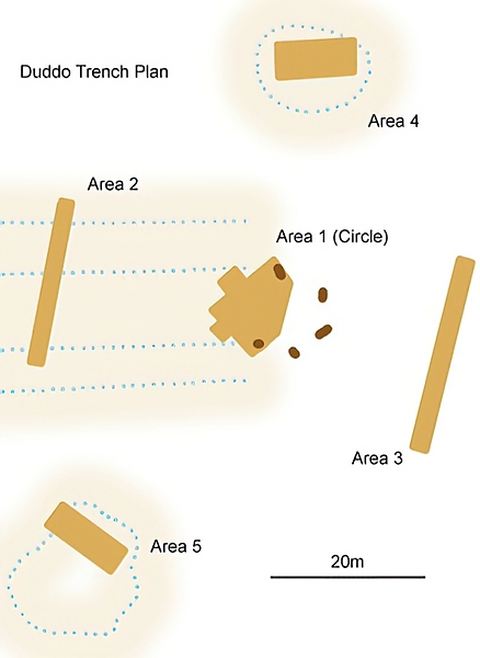
PlanIt was also important to establish the original morphology, or shape, of the monument. Were those re-erected stones in the correct position? Are there any other stone sockets? The trench at Area 1 (the trenches are shown as brown on the diagram) would investigate this.
Aerial images had hinted at a possible linear feature running in a westerly direction from the stones as indicated by the dotted horizontal lines in the diagram. Could this have been some sort of processional avenue to the site? Did it extend east of the circle? Another area for investigation and the reason for trenches at Areas 2 and 3
Was there ever an outlying circle as some early reports suggested? Areas 4 and 5 would be opened up in response to some strong anomalies which appeared on a geophysical survey undertaken in July 2007 to help plan the 2008 dig. Finding the elusive outer circle was of interest here. Area 4 was an area roughly similar to that of the Duddo circle. Area 5 is of a similar area though managed to produce even stronger geophysical data.
By producing the first comprehensive survey would also be invaluable in the continued management of the monument. It is certain that the site has suffered in the past from its agricultural situation; the plough is not kind to archaeology.
More information could only help preserve what stands today so that advances in technology can look more closely at the evidence in the future.

