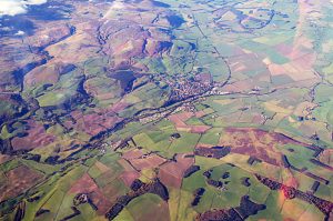
The Milfield Plain
The Milfieild Plain extends out from the northern Cheviot hills. It is a fairly flat, fertile area crossed, and irrigated, by the rivers Till and Glen which feed the Tweed. The plain contains evidence of some of the earliest occupation and agriculture in England with evidence dating back as far as 4000BC.
 The Cheviots were sculpted into the rounded shapes we see today diring the last ice age when they were ground down by an ice sheet estimated to have been a kilometer thick. When the ice eventually melted the water flowing north was naturally dammed and formed an enormous lake, sometimes known as Lake Ewart. This lake covered the 20 square kilometer area we know as the modern Milfield Plain.
The waters washed huge quantities of gravel down from the Cheviots and this covered the bed of the lake.
Around 8000BC the lake drained away, probaly through a breach at Etal, leaving an area of rich ground and abundant resources.
The photograph clearly shows the bulk of the northern Cheviot foothills to the top left with the ancient lake bed on the right. The line of the modern road would have almost run along the water’s edge.
Marshy wetlands formed close to the rivers Glen and Till and these would have been home to fish and birds providing a valuable resource for early hunter-gatherers occupying the area. Evidence for the arrival of such mobile groups has been found in the form of Mesolithic stone tools left behind on the gravel plain next to the wetlands. Excavations at Corby’s Crag and Goatscrag have revealed signs of the temporary lean-to dwelling structures they would have built for shelter.
